Man stranded on cliff following non-existent trail on Google Maps was rescued by helicopter team،
Everyone assumes that Google Maps is reliable in getting you from point “A” to point “B” quickly and safely. Sometimes this is not the case. Last Saturday, a hiker attempting to climb Mount Fromme in Canada had to be rescued from a cliff where he was stuck after following instructions on
Google Maps. These directions led him through a path that did not exist. By
Fox Newsa helicopter rescue team as well as a rope team had to be deployed to rescue the hiker.
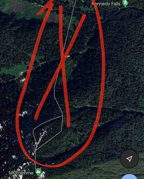
The helicopter and rescue team were sent to the rear of Mount Fromme, located near Vancouver, British Columbia. Officials said the Kennedy Falls area from which the
man was attempting to climb Mount Fromme has no trails, is very steep and was the site of a previous death. In addition to following Google Map directions to hike a trail that didn’t exist, officials said the man was unequipped to accomplish his goal because he wasn’t carrying a flashlight and had very little visibility. hiking gear with him.
The hiking trail seen on Google Maps by the hiker did not exist
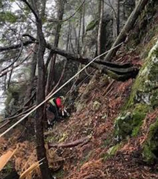
The rescue team was initially unable to spot the hiker because of trees blocking their view. Two of the technicians who were flying in the helicopter were taken down the mountain and had to climb on foot. After finding the stranded hiker, they placed him in a harness and took him to an area where all three could be safely picked up by the helicopter.
In September, a similar situation occurred when a hiker in the same area attempted to follow a trail seen on Google Maps that didn’t exist. The relief group said it tried to get Google to remove the nonexistent leads, but did not receive a response from the company.
Rescuers were lowered down the mountainside from the helicopter
Seeking to prevent a similar situation from happening again, the rescue group issued some warnings to hikers. “First, it is simply not appropriate to navigate in nature using ‘urban map’ programs like Google Maps,” the team said. They recommended hikers go “old school,” using a compass with a paper map and following signs posted in the area that warn of impending dangers.
If you must use a phone-based navigation
app, the rescue group suggests using one designed for the outdoors and preloaded with a topographical wilderness map.